Showing posts with label Santa Fe Trail. Show all posts

Friday, February 3, 2012

Halfway to Santa Fe ~ Pawnee Rock


While doing some organizational work on my photo archives, I discovered a few photos that I had intended to post last spring. En route home from a photo "safari" to the Red Hills, we (Melody dog and I) had stopped briefly at Pawnee Rock, a little-known, but historically significant, landmark on the plains.In spite of its significance, I never got around to posting my photos.


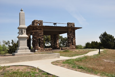
Although Pawnee Rock State Historic Site is not exactly what you might call a "Wow!" place visually, it is a place of importance to those interested in the Santa Fe Trail in particular, or Plains Indians and Kansas history in general. Driving US 56 between Great Bend and Larned can see the mound from the highway, and it doesn't take a lengthy detour to drive over and check it out.


Prior to the arrival of European explorers and settlers, plains Indians used the mound, then about 150 feet taller than the surrounding flat-lands*, as an observation point from which to spot the vast herds of American bison which roamed the area, as well as warring rival tribes. Later on, it was also used to spy the wagon trains on the Santa Fe Trail which were crossing their hunting grounds.  Trail [travelers] were undoubtedly glad to reach Pawnee Rock as it meant they were half-way to Santa Fe, but they also knew that Indians could pose a danger at this point. In 1859, nearby Fort Larned (originally known as the "Camp on Pawnee Fork") was established making this stretch of the roadway a little more secure for travelers.


How did Pawnee Rock get its name? It depends upon whom you ask. Kansaspedia, a website of the Kansas Historical Society, outlines three versions of the story:
"Many stories have been told to explain how Pawnee Rock got its name. One tale relates that it was sacred ground for the Pawnee Indians who held tribal councils on its flat top. Another describes a great battle in which a small band of Pawnees was destroyed by a force of Kiowas, Cheyennes, and Arapahos. Both of these attribute the name to events in Pawnee lore that occurred near the Rock. A tradition among white plainsmen was that the Rock received its name in 1826 from an embarrassing mistake by Kit Carson. A raw youth of seventeen, Carson was on his first trip into the West. The wagon train with which he was working camped for the night near the Rock. He was given guard duty. In the dark, he shot his own mule, thinking it was an attacking Pawnee. His unkind associates commemorated his unfortunate experience with the name, Pawnee Rock."

Pawnee Rock State Historical Site is now administered by the Kansas Historical Society. The stone monument was dedicated in 1912. Pawnee Rock was added to the National Register of Historic Places around 1970.


* Modern visitors can easily observe that the "summit" of Pawnee Rock is somewhat lower than 150 feet. During the 1870s, the engineers building the nearby railway running parallel to the old Santa Fe Trail removed much of the rock for the purpose of fortifying the road bed. Some early settlers also made use of the stone as building material, and as a result, Pawnee Rock is now about half its original height.

Looking out from the monument across the croplands, use your imagination. Visualize a vast ocean of grass, enormous herds of American bison, or a line of oxen carts slogging along the Santa Fe Trail. That was the scene here - not that many generations ago.


**************************

Learn more about Pawnee Rock at these sites:

I especially recommend this page at Legends of Kansas for its detailed history of the region and the town of Pawnee Rock: http://www.legendsofkansas.com/pawneerock.htmli 

This web page has a number of additional photos of Pawnee Rock, as well as interesting reading about the Smoky Hill and Santa Fe Trails. Scroll down to see Pawnee Rock photos:
Kansas State Historical Society: 

Photos and text (except for that attributed to Kansas Historical Society)
copyright Frank Thompson


Friday, June 25, 2010

Cimarron National Grasslands


No county was more severely effected by the devastating Dust Bowl years than Morton County, Kansas. Barely a decade after farmers had begun growing wheat in the desolate region, drought and unwise cultivation and cattle grazing practices turned the land into a sea of blowing sand. Congress bought out* the bankrupt farmers, and in 1938, the U.S. Conservation Service began restoring the native prairie. In 1954, the National Forestry Service assumed management of the grasslands, of which 108,175 acres of shortgrass prairie and sandsage prairie became the Cimarron National Grasslands in 1960.


My visit was a diversionary side trip from family time with Nancy's parents in Sharon Springs. I would not normally have found the two hour plus drive from Wallace County to Morton County to be very interesting, but I enjoyed viewing the huge fields of wheat, and especially noting the increasing levels of ripeness as I headed south. A field of golden wheat blowing in wind, "ripe unto harvest" is a glorious sight!

I did not anticipate spending much time in the grasslands, but even that was cut short as I was feeling the effects of a "sour tummy." Knowing there was an element of luck involved in finding and photographing the elk, pronghorns, and deer native to the area, I concentrated on landscape and wildflower shots on Tuesday evening, hoping to check with park rangers on the whereabouts of the large game the next morning. After a good night's rest, I headed directly back toward Sharon Springs with my lingering belly ache. The only wildlife I saw in the Grasslands was through my car window - not my view finder: a handful of turkeys and a coyote. The good news was that I did not see any rattlesnakes either.

Morton County is in the extreme southwest corner of the state of Kansas. It would be impossible to get any further away from my home in Overland Park without leaving the state. A few miles west of town, and located within the Cimarron National Grasslands, is a marker designating the approximate location where the states of Kansas, Colorado, and Oklahoma meet. Even with modern global positioning systems, there is some discrepancy over the exact spot.

The county seat of Elkhart (pop 2233) appears more prosperous than many like-sized communities in the heartlands, perhaps due to the numerous oil and gas wells in the vicinity. Its business district seemed to be active, and many residential neighborhoods were attractive and well-maintained.
 
The topography within the grasslands is mostly rolling and hilly, but there are a few notable landmarks such as the Point of Rocks, shown immediately above in a closeup view, and seen from a distance in the title photo at the top of this posting. Point of Rocks is the third highest point in the state of Kansas at an elevation of 3,540 feet. It is believed that the area's plains Indian tribes used the overlook to scout the countryside for bison, intruders, etc., and some historians speculate that native Americans may have stampeded bison over the cliff in order to expedite the killing of numerous animals needed for food and other purposes, a common practice.**
 

The stone post shown above is one of many marking the Cimarron Cut-off of the Santa Fe Trail which traverses 23 miles across the Grasslands. Travelers relied on artesian wells to supply water for their journey across the high prairie. The wooded area behind the monument is along the Cimarron River which is constantly flowing 12 to 18 inches under the surface, but only seen above ground during flood situations. According to the journals of those who traveled the trail, there were few if any trees along the river at that time.

A good way to explore the Grasslands is to follow the 50 mile self-guided auto tour outlined in a free pamphlet available at the Forestry Service office in Elkart (US Hwy 56). Several wells crucial to early voyagers are among the sights, including the artesian well shown at right. Normally this well's water pressure is sufficient to bring water to the surface without use of the windmill, but the mill was hooked up and functional on the day of my visit. Not too far off of K-27 highway is a recreation area - a shady retreat that includes campgrounds, picnic areas, and fishing ponds.


 One benefit of visiting the Cimarron Grasslands in spring (especially following a rainy spell) is the presence of a variety of wildflowers, many of which were unfamiliar to me. The high prairie's short grasses, sand and sage are vastly different to the environments to which I am accustomed. Below are several of my favorite wildflower images:

Prairie Coneflower

 Prickly Pear Cactus

Plains Blackfoot Daisy, aka Rock Daisy

You may well encounter, as I did, cattle on the roadways. This commercial enterprise, as well as oil and gas wells, are operated under license with the US Department of Agriculture / Forestry Service, and provide a steady source of income for the local school district.

####################

*Congressional buy out of farmers - a reminder that "bail-outs" are not a new practice, and that sometimes you have to wait a few years or even decades to fully determine the merits of that action. 

** Those quick to condemn this type of mass killing should be reminded that the Indians did not kill for sport, but to sustain their meager daily needs. These indigenous peoples were keepers of the land and its creatures, and found uses for the entire animal - not just the meat.   

####################

Recommended Link: Well-done site; learn more about the grasslands at:  www.naturalkansas.org/cimarron

A note about lodging: Elkhart has two locally owned motels, one bed and breakfast in town, and one rural B&B. I chose the latter for my one night stay - the Cimarron Bed and Breakfast, which is actually in Oklahoma (by less than a mile), and is a comfortable, modern farm home surrounded by corn fields. Linda and Kyle Martin are gracious hosts, and Linda cooks up a mean breakfast that includes eggs fresh from the hen house and French toast made of home-baked bread.