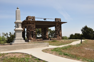
While doing some organizational work on my photo archives, I discovered a few photos that I had intended to post last spring. En route home from a photo "safari" to the Red Hills, we (Melody dog and I) had stopped briefly at Pawnee Rock, a little-known, but historically significant, landmark on the plains.In spite of its significance, I never got around to posting my photos.
Although Pawnee Rock State Historic Site is not exactly what you might call a "Wow!" place visually, it is a place of importance to those interested in the Santa Fe Trail in particular, or Plains Indians and Kansas history in general. Driving US 56 between Great Bend and Larned can see the mound from the highway, and it doesn't take a lengthy detour to drive over and check it out.
Prior to the arrival of European explorers and settlers, plains Indians used the mound, then about 150 feet taller than the surrounding flat-lands*, as an observation point from which to spot the vast herds of American bison which roamed the area, as well as warring rival tribes. Later on, it was also used to spy the wagon trains on the Santa Fe Trail which were crossing their hunting grounds. Trail [travelers] were undoubtedly glad to reach Pawnee Rock as it meant they were half-way to Santa Fe, but they also knew that Indians could pose a danger at this point. In 1859, nearby Fort Larned (originally known as the "Camp on Pawnee Fork") was established making this stretch of the roadway a little more secure for travelers.
How did Pawnee Rock get its name? It depends upon whom you ask. Kansaspedia, a website of the Kansas Historical Society, outlines three versions of the story:
"Many stories have been told to explain how Pawnee Rock got its name. One tale relates that it was sacred ground for the Pawnee Indians who held tribal councils on its flat top. Another describes a great battle in which a small band of Pawnees was destroyed by a force of Kiowas, Cheyennes, and Arapahos. Both of these attribute the name to events in Pawnee lore that occurred near the Rock. A tradition among white plainsmen was that the Rock received its name in 1826 from an embarrassing mistake by Kit Carson. A raw youth of seventeen, Carson was on his first trip into the West. The wagon train with which he was working camped for the night near the Rock. He was given guard duty. In the dark, he shot his own mule, thinking it was an attacking Pawnee. His unkind associates commemorated his unfortunate experience with the name, Pawnee Rock."
* Modern visitors can easily observe that the "summit" of Pawnee Rock is somewhat lower than 150 feet. During the 1870s, the engineers building the nearby railway running parallel to the old Santa Fe Trail removed much of the rock for the purpose of fortifying the road bed. Some early settlers also made use of the stone as building material, and as a result, Pawnee Rock is now about half its original height.
Looking out from the monument across the croplands, use your imagination. Visualize a vast ocean of grass, enormous herds of American bison, or a line of oxen carts slogging along the Santa Fe Trail. That was the scene here - not that many generations ago.

**************************
Learn more about Pawnee Rock at these sites:
I especially recommend this page at Legends of Kansas for its detailed history of the region and the town of Pawnee Rock: http://www.legendsofkansas.com/pawneerock.htmli
This web page has a number of additional photos of Pawnee Rock, as well as interesting reading about the Smoky Hill and Santa Fe Trails. Scroll down to see Pawnee Rock photos:
Kansas State Historical Society:
Photos and text (except for that attributed to Kansas Historical Society)
copyright Frank Thompson


