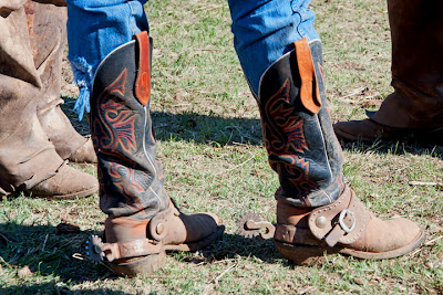
Shotgun Quiz: There were six major cattle trailheads in early Kansas - each a rough and tumble place where trail hands could expect all kinds of excitement when the herd reached its destination and was sold. How many of the six can you name? Dodge City and Abilene come to most minds immediately, then Wichita. After a little thought, some will remember that Newton and Ellsworth had their days of "glory" as well. Hays? No, not Hays. I guess the image below has given it away by now. It's Caldwell - "The Border Queen." Never heard of it? Well belly up to the bar, cowhands, I'll tell you about that wicked "Border Queen," Caldwell, Kansas.
Located on the Chisholm Trail just north of the Kansas state line, and the first town outside of Indian Territory, Caldwell became an eagerly-awaited destination for dusty, bored cowboys ready to let off a little steam en route to the rail heads at Wichita and Abilene. When the Santa Fe Railway extended its line to Caldwell in 1879, the little town known as the Border Queen grew quickly, as did the numbers of saloons, gambling houses, and brothels. One Caldwell tour guide and historian has been quoted as telling visitors that his hometown once had more prostitutes per capita than any place in the world. [I guess we'll just have to take his word for that, because however would you, if you were so inclined, research that peculiar topic?]
 |
| 1881 Opera House |
 |
| Border Queen Museum Exhibits |
 |
| Chisholm Trail Marker and mural |
Kathy Weiser, in her article "Caldwell - The Wicked Border Queen," reports that "...between 1879 and 1885, Caldwell 'boasted' a higher murder rate, and loss of more law enforcement officers than other more famous cowtowns. During this period, violence claimed the lives of 18 city marshals, leading a Wichita editor to write, 'As we go to press hell is again in session in Caldwell.'"*
Visitors to Caldwell can see what is left of an authentic Boot Hill - no cartoonish grave markers or made-up names here to lure tourists. It is believed there were once approximately 60 graves in Boot Hill, but many of the markers have disappeared over the ages. How many bodies lie below the wheat fields surrounding the current cemetery? Who knows?
Located south of town on US Highway 81, on the route of the old Chisholm Trail, is an evocative reminder of those who rode the long, dusty trail - "The Ghost Riders Silhouettes." The monument was added to the Sumner County landscape in 1995 thanks to local labor and donations. How appropriate that at the precise moment I began to take photos standing next to one of the trail's successors (the highway), a train would be speeding along on another.
A word about Jesse Chisholm: I was surprised to learn that Jesse Chisholm never participated in any of the cattle drives along the Chisholm Trail, and had passed away by the time the larger numbers of cattle herds were being driven to Kansas. The son of a Scottish merchant and slave-trader father and a Cherokee mother, Jesse became a master of a number of Indian languages and dialects, a guide and interpreter, and the owner of trading posts in Indian Territory. It was these outposts that gave the Chisholm name to the trail.
Unlike some sister towns in Sumner County, Caldwell survives. Sumner City, which once had a population greater than any town in the county today, with a horse racing track visible from the air into the 1950s, has completely vanished**. The stories of early Caldwell are still around, as well as some remnants and relics of its exciting past.
Finally, Caldwell is also known as The Ornate Box Turtle Capital of Kansas Forgetting this during my visit, I failed to take a photo of the colorful box turtle mural on the side of one the town businesses.
*from a detailed account of Caldwell's early history at: www.legendsofamerica.com/ks-caldwell.html
** More on the disappearance of Sumner City and the alleged role of one of my Hackney ancestors in its demise will be explored someday in a posting of Memories from My Life's Journey
*************
Nearby:
Enroute to Caldwell, I sought out the site of the old mill at Drury, a few miles east of Caldwell on the Chikaskia (pronounced shuh-KASK-ee locally) River. My 94-year old mother still has memories of picnics and wading in the cool waters. I'm not certain, but think her papa might have taken grain there for milling, although the mill at Oxford would have been closer. The mill building itself burned to the ground in 1953 and only some of its foundation and the dam survive. There is a small park at the now, with picnic and restroom facilities.
Educator, naturalist, and photographer Larry Miller has reported that David Carradine and Hollywood film crews used the area as a movie location in 1973 and showed photos of it while being interviewed by Johnny Carson on the "Tonight Show." Carradine was involved in the "Kung Fu" television series at the time, but I have no knowledge if portions of that show were filmed at Drury or the Chikaskia River.
Other Links of Interest:
The "Official Sesquicentennial Cattle Drive" ~ 400 head of Texas Longhorns will be driven from Caldwell to Ellsworth. Labor Day weekend. http://www.kansascattledrive2011.com/
The Official Caldwell, Kansas Web Site: www.caldwellkansas.com/
The Official Caldwell, Kansas Web Site: www.caldwellkansas.com/


